
This is an entry from Samuel Lewis’ A Topographical Dictionary of Ireland, published in 1837. It provides a pretty thorough description of Coolock, from the soil quality to the number of inhabitants, as well as its ‘big houses’, churches and schools. I have added some footnotes to expand on a few points mentioned by Lewis.
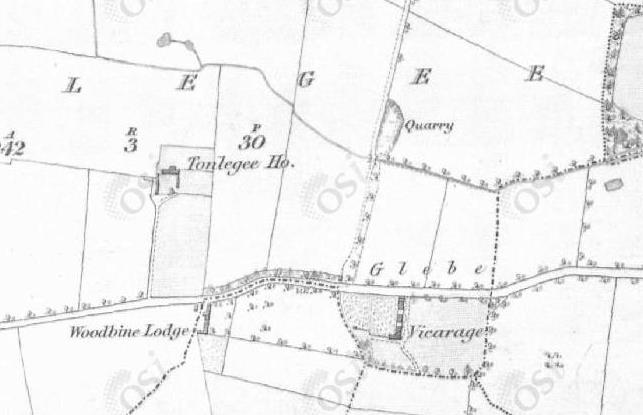
If you fancy perusing a map of Coolock from about this time, check out the Ordnance Survey Ireland website, specifically their mapviewer (click to open), which is free to use. On the right-hand menu choose ‘Historic 6″ B&W’ which is a bit easier to see than the colour version. The 6″ map dates from 1829-41 so suits Lewis very well.
Coolock, a parish, in the barony of Coolock, county of Dublin, and province of Leinster, 3 3/4 miles (N.N.E) from Dublin, on the road to Malahide; containing, 914 inhabitants, of which number, 190 are in the village, which contains 26 houses, and is a constabulary police station1. The parish comprises 1691 statute acres, as applotted under the tithe act: the soil is fertile, and well adapted for corn. Limestone abounds, and a quarry near the glebe-house is worked for agricultural and other purposes.2
There are numerous handsome seats and pleasant villas, from most of which are fine views of the bay and city of Dublin, with the adjacent country. Of these the principal are
Beaumont, residence of A. Guinness, Esq.3
Newbrook, of E.H. Casey, Esq.
Belcamp, of Sir H. M. J. W. Jervis, Bart.
Brookeville, of R. Law, Esq.
Coolock House, of H. Brooke, Esq.
Coolock Lodge, of T. Sherrard, Esq.
Shrubs, of W. White, Esq.
Bonnybrook, of T.W. White, Esq.
Newbury Hill, of A. Ong, Esq.
Priors Wood, of T. Cosgrove, Esq.
Gracefield, of R. Eames, Esq.
Lark Hill, of E. Hickson, Esq.
Moatfield, of M. Staunton, Esq.
Darendale, of F. Gogarty, Esq.
Clare Grove, of General A. Cuppage
Airfield, of Alderman Sir E. Nugent, Knt.
Cameron Lodge, of H. Jones, Esq.
The living is a vicarage, in the diocese of Dublin, and in the patronage of the Marquess of Drogheda, in whom the rectory is impropriate: the vicarial tithes amount to £249.4.71/2. There is a glebe house, with a glebe comprising 17a, 2r, 25p. The church, dedicated to St. Brandon, a neat edifice, was partly rebuilt and enlarged, by aid of a loan of £500 from the late Board of First Fruits, in 1818.
In the R.C. divisions the parish forms part of the union or district of Clontarf. The chapel was erected in 1831, at an expense of £800, raised by subscription : it is a very neat edifice, in the later English style, with a belfry over the principal entrance ; the interior is very well arranged and neatly decorated.4
The parochial school, for which a house was built at an expense of £300, the gift of Sir. Compton Domville, Bart., is supported by subscription, and attended by 30 or 40 children.5
A school of 30 children, for which a handsome cottage has been built in the grounds of Beaumont, and an infants’ school in connection with it, are wholly supported by Mrs. Guiness ; and in connection with the R.C. chapel is a school to which W. Sweetman, Esq., gives £20 per annum.
On a common near the church which is now enclosed, a great concourse of persons connected with Emmet’s insurrection was assembled, ready to march into Dublin at the appointed signal. In the grounds of Newbrook, through which flows a small stream, are the walls of a holy well, dedicated to St. Donagh ; the spot is much resorted to, on St. John’s Eve, by poor sick people, who, after rubbing themselves against the walls, wash in a well in the adjoining grounds of Donaghmede.6 In the grounds of Shrubs was anciently a nunnery and human bones are frequently dug up there.7 There are ancient raths in the grounds of Bonnybrook and Moatfield.8
————————————————————————————————
1 This refers to the Royal Irish Constabulary who had come into force the previous year in 1836. A separate police force, the Dublin Metropolitan Police, were in the capital. They were replaced in 1922 by the Garda Síochána.
2 The quarry was situated in the present day park at Millbrook Avenue and Streamstown Road in Donaghmede. (If this park has a name, I can’t find it.) Essentially, it was just behind the Donahies School. The Glebe House referred to was situated where the youth centre is on the Tongalee Road.
3 Yes, it is that Arthur Guinness. However, he had died in 1803. This building still exists and is now part of Beaumont Nursing Home. I will discuss these ‘big houses’ individually in later posts.
4 Now known as St. Brendan’s, a thatched chapel had been erected in 1820, with a larger chapel built in 1831. Apparently, the foundation stone of the 1831 chapel is now in the garden of the present day Community Centre.
5 This school stood where the Bank of Ireland is in the village today.
6 St. Donagh’s Well seems to have been located in what is now the green between Holy Well and St. Donagh’s Road in Donaghmede.
7 Shrubs House stood on the hill where Atlantic Homecare is, opposite Northside Shopping Centre. The bridge there over the Santry River was known as Shrubs Bridge.
8 Moatfield House stood just outside Coolock Village, where Cadbury’s is today, and the mound can still be seen. Bonnybrook House was located where Riverside Road is today.
